


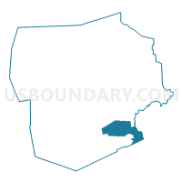
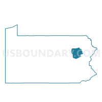
FOSTER TWP WD 01, Luzerne County, Pennsylvania
About
Outline

Summary
| Unique Area Identifier | 660897 |
| Name | FOSTER TWP WD 01 |
| County | Luzerne County |
| State | Pennsylvania |
| Area (square miles) | 24.36 |
| Land Area (square miles) | 24.10 |
| Water Area (square miles) | 0.26 |
| % of Land Area | 98.95 |
| % of Water Area | 1.05 |
| Latitude of the Internal Point | 41.03573120 |
| Longtitude of the Internal Point | -75.82314120 |
Maps

Graphs
Select a template below for downloading or customizing gragh for FOSTER TWP WD 01, Luzerne County, Pennsylvania


Neighbors
Neighoring Voting District (by Name) Neighboring Voting District on the Map
- BUTLER TWP DIST 01, Luzerne County, PA
- BUTLER TWP DIST 02 (UPPER LEHIGH), Luzerne County, PA
- DENNISON TWP Voting District, Luzerne County, PA
- EAST SIDE Voting District, Carbon County, PA
- FOSTER TWP WD 02, Luzerne County, PA
- FREELAND WD 01, Luzerne County, PA
- FREELAND WD 02, Luzerne County, PA
- KIDDER TWP DIST SOUTH, Carbon County, PA
- LEHIGH TWP Voting District, Carbon County, PA
- WHITE HAVEN Voting District, Luzerne County, PA
Top 10 Neighboring County Subdivision (by Population) Neighboring County Subdivision on the Map
- Butler township, Luzerne County, PA (9,221)
- Freeland borough, Luzerne County, PA (3,531)
- Foster township, Luzerne County, PA (3,467)
- Kidder township, Carbon County, PA (1,935)
- Dennison township, Luzerne County, PA (1,125)
- White Haven borough, Luzerne County, PA (1,097)
- Lehigh township, Carbon County, PA (479)
- East Side borough, Carbon County, PA (317)
Top 10 Neighboring Place (by Population) Neighboring Place on the Map
- Freeland borough, PA (3,531)
- Beech Mountain Lakes CDP, PA (2,022)
- White Haven borough, PA (1,097)
- Hickory Hills CDP, PA (562)
- East Side borough, PA (317)
Top 10 Neighboring Unified School District (by Population) Neighboring Unified School District on the Map
- Hazleton Area School District, PA (72,891)
- Crestwood School District, PA (20,018)
- Weatherly Area School District, PA (5,055)
Top 10 Neighboring State Legislative District Lower Chamber (by Population) Neighboring State Legislative District Lower Chamber on the Map
- State House District 122, PA (65,249)
- State House District 116, PA (65,038)
- State House District 117, PA (60,701)
Top 10 Neighboring State Legislative District Upper Chamber (by Population) Neighboring State Legislative District Upper Chamber on the Map
- State Senate District 20, PA (273,416)
- State Senate District 27, PA (256,971)
- State Senate District 14, PA (250,131)
Top 10 Neighboring 111th Congressional District (by Population) Neighboring 111th Congressional District on the Map
Top 10 Neighboring Census Tract (by Population) Neighboring Census Tract on the Map
- Census Tract 2166, Luzerne County, PA (9,221)
- Census Tract 202, Carbon County, PA (6,370)
- Census Tract 2168, Luzerne County, PA (3,565)
- Census Tract 2167, Luzerne County, PA (3,531)
- Census Tract 2154, Luzerne County, PA (2,530)
- Census Tract 201.06, Carbon County, PA (2,252)